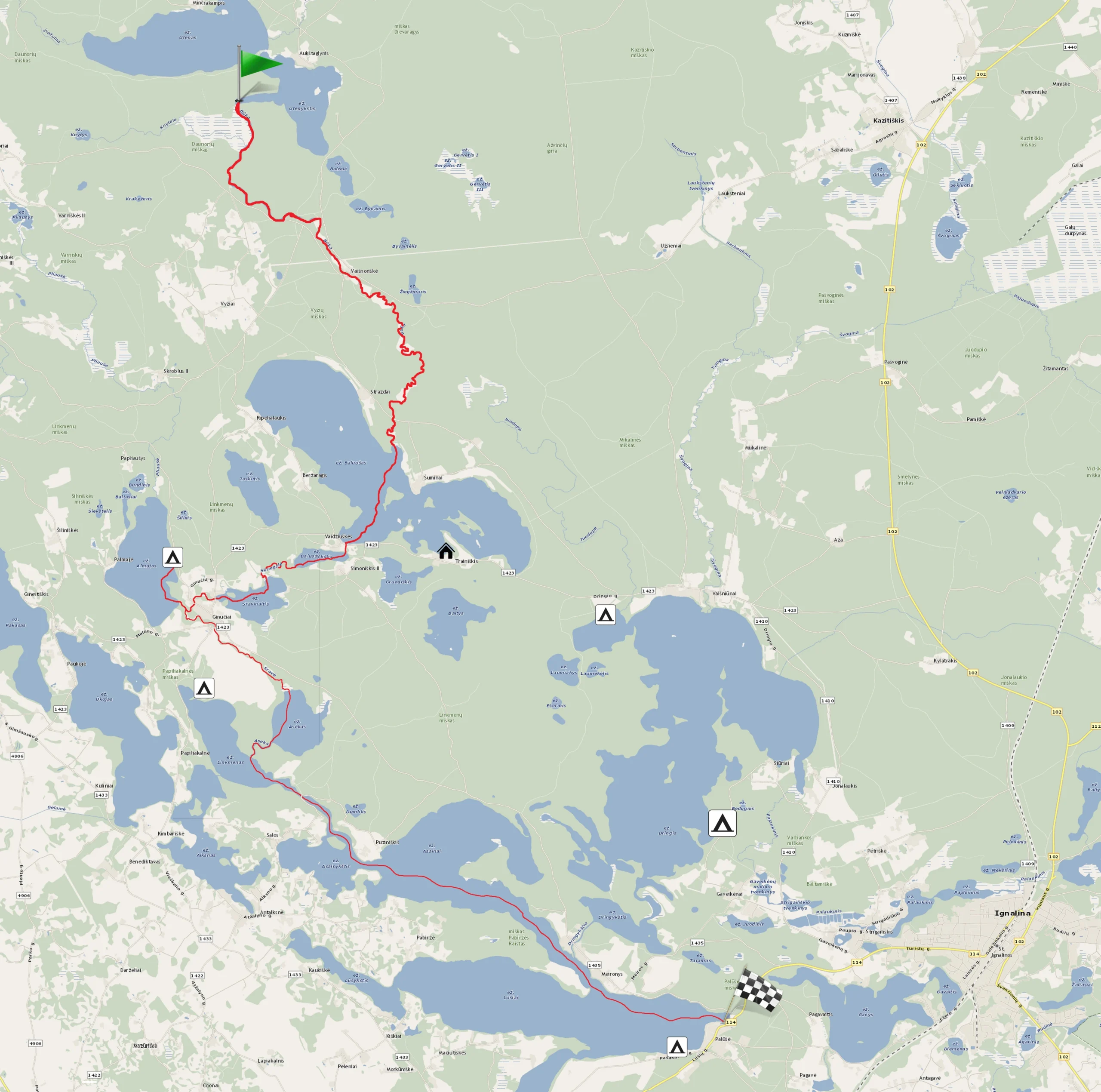
River Būka – Lake Lūšiai (up to Palūšė village)
10.00 – 20.00 €
- ~9 hours
- ~27 km
Inquire and book canoes
First day's route (~17 km; ~6 hours): River Būka and lakes to Almajas campsite
Second day's route (~10 km; ~4 hours): Almajas campsite and lakes to Palūšė
Day 1
Būka and lakes to Almajas campsite
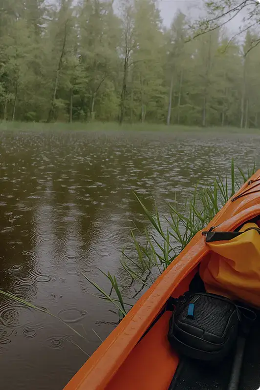
After jumping into the canoes on Lake Utenykštis, paddle a few hundred meters keeping to the right side of the shoreline to bypass the Utenykštis lake cape. Continue keeping to the right bank, paddle through the Lašmens strait, known for its rich marsh flora. After overcoming the marsh reeds, you’ll cross the strait and continue your journey on the Būka River. During the trip, you can rest in ethnographic areas and campsites set up along the river. The banks of Būka are bordered by forested woods, enriching its waters. On your left, in the direction of your paddle, is the Ažvinčiai forest, and on the right, the Vyžiai forest. So, paddling this river, you’ll not only get acquainted with the rich flora and fauna of the rivers but also confirm that the Būka River is one of the cleanest rivers in Lithuania!
In the past, the Būka River was used for log rafting. You know that the river’s water level changes in certain areas, so the water level was artificially raised to ensure optimal log transportation. You’ll find remnants of wooden dams during your journey!
About a kilometer from the start of your journey (from the Būka’s source at Utenykštis), you’ll reach the Ineiga rest area. Here you can take a break after the start. But don’t linger too long, as the journey has just begun!
You might encounter Water Lily families while paddling. Water Lilies are included in the Red Book, so please act responsibly – do not pick or harm them! If you like to pick plants as souvenirs, look around and pick Water Mint hidden among the reeds on the riverbanks. Their flowers are not only beautiful – at the end of the trip, you can brew delicious mint tea for yourself and your travel companions!
Soon you’ll notice the village of Vaišnoriškės, recognizable by the XIX – XX century style of the residents’ buildings, from whose yards wooden piers and small bridges stretch out into the river. Bypassing the piers, you’ll pass a small bridge necessary to extend the Tauragnai township. and the Braslavas township road. Next to that small bridge on your left, notice the ethnographic area: once there stood an inn, mentioned since 1765. The first homestead in this area was established in 1830. Later, four more were built.
After passing the mentioned Vaišnoriškės and the road bridge, the Būka narrows and becomes winding. This section of the Būka River is characterized by some deep spots and a more intense current. And, of course, how could there not be fallen trees across the river? You’ll find more than one, so you may need to carry some canoes over logs or on land along the riverbanks. Remember, a wet tree is slippery, the riverbed is not always even, and the current can disrupt balance. Be coordinated, unless you want to take a dip in the swift waters of Būka. J
Note that the river sometimes has bays that look like branches of the river. You’ll recognize the true riverbed by paying attention to the current – the free flow of water and the movement of plants.
And so, you’ve completed your journey on the Būka River. Its conclusion is adorned by the Baluošas Lake, rich with seven islands, which you’re now entering. The silence of Baluošas Lake is maintained by pine forests, whose resinous scents you probably already smell. Upon entering Baluošas, keep to the right side and you’ll find the Adomragis rest area. Here, refresh yourself, as a diverse range of Aukštaitija waters awaits you until the Almajas campsite!
At the Adomragis rest area, especially at the tip of the promontory, there is a clear and convenient shore inviting you to swim. It’s a great place for a dip, but not for leaving trash: be kind to nature and don’t leave litter, as there are no bins here. You’ll dispose of it in a container at the Almajas campsite, but until then, collect trash in your canoe’s bag.
So, after snacking and resting, it’s time to decide which direction to paddle. It depends on your strength and remaining supplies.
THERE ARE 2 OPTIONS TO CROSS BALUOŠAS LAKE:
First option (~1.5 km, ~20 min.) – paddle straight from the Adomragis rest area to the stream connecting Baluošas and Baluošykštis lakes. It’s about 1.5 km or 15-20 minutes of paddling. Choosing this direction, paddle to the opposite lake shore. On the left should be Liepų Island, on the right – a promontory called Beržaragis. From the Beržaragis promontory, you’ll see a bridge under which the connecting stream flows.
Second option (~4.5 km; up to ~1.5 hours) – explore the natural wonders of Baluošas Lake by visiting Ilgasalė Island. It’s a unique hydrographic formation in Lithuania, as Ilgasalė is the only island in Lithuanian lakes with a small lake on it.
To visit the most beautiful spots of Lake Baluošas (if you chose the second option), paddle from the Adomragis campsite along the left bank of Baluošas. Soon you’ll see the ethnographic village of Šuminai, first mentioned in historical sources in 1784. Under the name Pabaluošė. In this village, there is a pine tree about 300 years old. However, the pine tree does not make Šuminai village famous as much as the historical fact that in 1972, the famous Lithuanian film “Tadas Blinda” was filmed here, and every resident of Šuminai village will show you the “Tadas Blinda villa” standing here.
Leaving Šuminai village, paddle past Degėsio Island towards the last and longest island of Baluošas Lake – Ilgasalė. Reaching the southeastern end of Ilgasalė, paddle into the bay, where you can find a stream through gaps in the vegetation and enter with your canoes.
After paddling back from the Ilgasalė lakelet, return to the same place and direction you paddled from Šuminai village, then turn your canoes left and head southeast, keeping to the Baluošas shoreline. As you paddle, you’ll see a promontory in the distance. After rounding the promontory, if you still have time and energy, you can briefly enter the bay and visit the village of Trainiškis, visiting the Trainiškis landmark – an 800-year-old oak tree, which fell to the ground due to a strong storm in 2016. Since then, visitors can view not only the trunk of this historical tree but also its top!
Exiting the Trainiškis bay, on the left side you’ll see another small promontory. From there, paddle straight towards another, larger promontory visible in the distance. After rounding it and always keeping to the left shoreline, you’ll enter a large Baluošas bay, at the end of which you’ll see a stream about 150 m long, connecting Baluošas Lake with Baluošykštis Lake. This swift stream will carry you into another adventure-filled lake area.
Paddle along Baluošykštis until you reach the lake’s outlet, leaving Simoniškis village on the left and Vaidžiškiai village on the right. After crossing the lake, slightly to the left, among the reeds, you’ll notice the source of the Skriogžlė stream.
Skriogžlė is about 0.9 km long. Skriogžlė may seem like a narrow and deep river with several sharp bends. The banks of this river are covered with trees, making the river slopes quite steep. Storms have knocked several trees into the river, but you can overcome them by jumping with your canoe if you gain enough speed. After a few more bends, you’ll enter Lake Sravinaitis.
In Lake Sravinaitis, keep to the right shoreline until you reach an island shaped like a promontory. Bypass it on the left (the island will remain on the right), and you’ll reach the famous Ginučiai watermill.
The Ginučiai mill operated until 1968. A decade later, it was restored. Now the mill is declared a state-protected 19th-century technical monument. It houses a museum where you can see authentic old mill equipment. The mill museum is open from May to October (Tuesday to Saturday 10 am – 6 pm, Sundays 10 am – 3 pm).
Disembark on the right side of the watermill dam and carry your canoes over the dam. Don’t miss the great opportunity to swim in the water stream falling from the dam’s trough!
After splashing in the strong watermill stream, you’ll get into the carried canoes and enter the Srovė River. Soon you’ll reach the confluence with the Almaja River, flowing from Lake Almajas. Turn right into the Almaja River, paddling upstream directly into Lake Almajas. At the river’s source, you may feel its resistance, but once you enter the lake, you’ll rest. In Lake Almajas, paddle keeping to the right bank, and as you slowly row, you’ll pass a pointed promontory and see the Almajas rest area.
You’ve completed half the route: Almajas campsite is your halfway point, where you can rest and dispose of the accumulated trash in local containers and set up camp.
Day 2
Almajas campsite and lakes to Palūšė
Paddling from the campsite, keep to the left shoreline. At the outlet of Lake Almajas, paddling a short Almaja River, you’ll reach the confluence of rivers ahead – keep to the right side and paddle downstream – this will lead you into the Srovė River, whose channel will gradually curve to the left. After the river bend, you’ll pass the village of Ginučiai and the piers extending into the river, two road bridges. Passing the village, the river channel will be straighter, and after a few graceful turns, you’ll enter Lake Asėkas. In Lake Asėkas, keep to the right bank. After paddling more than half a kilometer, you’ll see the mouth of the Asėka River. This short, about 650 meters long, river connects the last Asėkas and Linkmenas lakes. Asėka has a wide bend, and the current here is very weak. Due to the abundant trees and grass vegetation on the riverbanks, moisture is retained, so beaver families breed in these areas.
The Asėka River will carry you into Lake Linkmenas.
Here you can choose several options: either continue the route without breaks or paddle to Papiliakalnė to look around from Ladakalnis.
If you want to visit Ladakalnis, you need to paddle to the opposite lake shore, deviating slightly to the right (on the map, Ladakalnis is marked with a red dot). Ladakalnis is a hill rising 176 m above sea level, from which you can count the lakes visible to the horizon. You’ll paddle about 1 km to Ladakalnis. However, you’ll forget about the distance when magnificent views open up before your eyes from the top of Ladakalnis: vast forest expanses, lakes hidden in the woods – Asėkas, Linkmenas, Alksnaitis, Alksnas, Ūkojas, and Pakasas will refresh your soul. Here you’ll gather strength for further travel through the lake-rich Aukštaitija.
After visiting Ladakalnis, paddle across Lake Linkmenas, keeping more to the right side. In the distance, you’ll see the Unkštis strait, connecting Linkmenas and Asalnykštis lakes.
If you didn’t visit Ladakalnis and have just arrived from the Asėka River, turn your canoes left and keeping to the left bank, after about half a kilometer, you’ll reach the Unkštis strait, connecting Linkmenas and Asalnykštis lakes.
Entering the Unkštis strait, you’ll paddle a little over 1 kilometer, and halfway through the strait’s trajectory, you’ll pass under a wooden pile bridge. This bridge connects the Salų peninsula visible on your right with the age-old Linkmenai forest on the left.
The Salų peninsula is special because it houses two villages: Salos I and Salos II. Both are in a kind of peninsula, washed by the Asalnykštis, Linkmenas, Alksnas, and Alksnaitis lakes. The only road for the peninsula’s village residents to travel by land leads from the village of Antalksnė. The Salų villages stand out for their unique architecture and layout, so a cultural reserve has been established here. Unfortunately, only a house and a barn from the 19th century remain. Other buildings were built in the early 20th century.
The peninsula we’re talking about is on your right as you paddle. On the left is also a very interesting historical site – the Puziniškis hillfort, covered with pines and birches, against which the aforementioned wooden bridge leans. The steep, up to 20 meters high, slopes of the hillfort are surrounded by remnants of a defensive rampart from the west. Perhaps you’d like to visit here too?
While deciding whether to paddle further or climb the hillfort, look at the water lapping the strait’s banks: you’ll see green organisms attached to various places, resembling corals. These are freshwater sponges – Lake Sponges (Spongilla Lacustris). Lake sponges and corals are related fauna, classified as simple invertebrates.
The strait is only one kilometer long, but around it are full of natural wonders and ethnographic objects. After overcoming the Unkštis strait, you’ll paddle into Lake Asalnykštis.
When you enter Asalnykštis, don’t get lost – keep to the left shoreline, and as you paddle in the right direction, Gimžiškės Island will wave on your right. As you paddle, you’ll see a strait in the distance, which, after crossing, will lead you into Lake Asalnai. On the left side of the strait, you’ll see the village of Puziniškis. This area also has its interesting history: in 1919, when Poland occupied the Vilnius region, a demarcation line separating Lithuanian and Polish-occupied territories ran through this village. The village of Puziniškis is located on a hill, from which a stunning view of the Asalnai landscape reserve opens up. After crossing the strait dividing the lakes, you’ll enter Lake Asalnai.
In Lake Asalnai, paddle straight, keeping to the right shoreline. Paddling in this direction, you’ll notice that this part of the lake begins to narrow. When you reach the narrow part of the lake (like a sleeve), on the left side, you’ll see the Dringykščia River (also known as Meira). The river flows from Lake Dringykštis, and just beyond the river, the sun warms the roofs of the farming village of Meironys, which will accompany you until you enter Lake Lusiai.
There is an interesting tradition in the village of Meironys: during Pentecost, farmers decorate their cows with flower wreaths and float them to the opposite cape’s shore, which locals call Pabiržis. There, the cows are released to graze freely until autumn and are floated back during Michaelmas. Milkmaids row by boat every morning and evening to milk the cows and bring the warm milk home.
So, after passing the village of Meironys on the left and Pabiržis cape on the right, you’ll enter Lake Lūšiai. From this point, keeping to the left shoreline, paddle ~1.5 km to the eastern shore of Lake Lūšiai towards the village of Palūšė.
Palūšė village is your finish line! At the finish line, we recommend visiting the Palūšė church with its bell tower, as it is the largest historical landmark of the village—a wooden church with a bell tower built in 1750! Climbing the stone-paved stairs, you’ll see that the church is well restored and cozy. The church stands on a hill, offering a pleasant view of Lake Lūšiai. This is the oldest wooden church in Lithuania, once featured on the 1 Litas banknote.