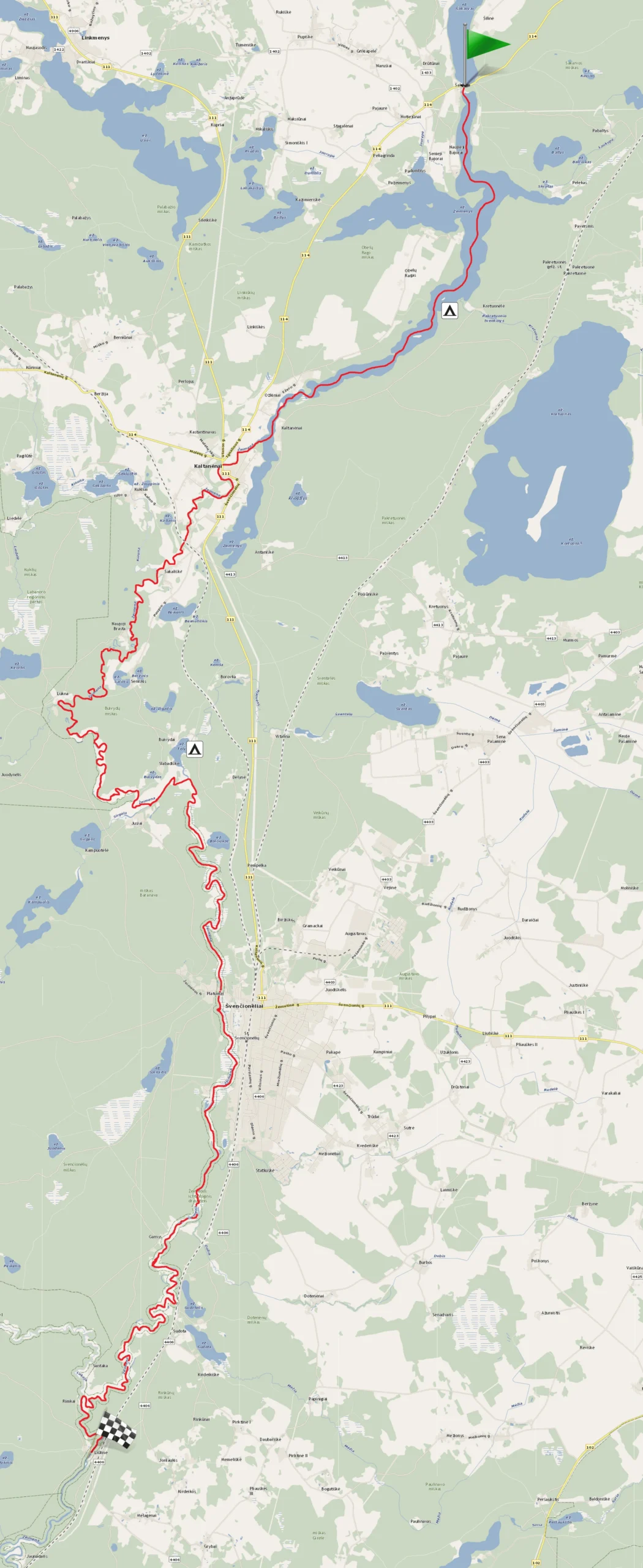
Lake Žeimenys – Žeimena River (From Šakarva village to Liūlinė village)
You’ll pass through Šakarva forests, Labanoras Regional Park, Buivydai forest, Baranava, and Švenčionėliai forests. You’ll also pass through the Žeimena ichthyological reserve, which protects spawning grounds for salmon, sea trout, and brown trout. As you finish, you’ll be accompanied by the rustling of Rikūnai forest.
10.00 – 20.00 €
- ~14.5 hours
- ~43.6 km
Inquire and book canoes
First day's route: From Lake Šakarva, through Lake Žeimenys and the Žeimena River to the Telio Lake campsite (~21 km, ~7 hours)
Second day's route: From the Telio Lake campsite, down the Žeimena River to Liūlinė village (~22.6 km, 7.5 hours)
Žeimena is the mother of rivers and lakes in Eastern Aukštaitija. It attracts water tourists with its wide and picturesque valleys, sandy cliffs embraced by pine forests, clear water, and sandy riverbed. Žeimena charms with its graceful bends and excellent campsites along the banks.
This river is very convenient—there are no artificial or natural obstacles. The water is always clear, and the current is calm and abundant. Therefore, canoeing here is pleasant for those who want an easy river journey, enjoy beautiful views, and travel with children while feeling safe.
Žeimena is a right tributary of the Neris River. It flows into the Neris 213 km from its mouth, near Santaka. The length of the Žeimena River from its source in Lake Žeimenys is about 82 km; its basin covers about 2800 km². It is rich in forests, many lakes, and wetlands. Therefore, the Žeimena River is abundant in water all year round. Its upper reaches consist of the cleanest waters in Lithuania, flowing from the network of rivers and lakes in the Aukštaitija National Park. The waters of Žeimena are also supplemented by rivers from the Labanoras Regional Park forests, such as Kiauna and Lakaja. Therefore, this “mother of rivers” in Aukštaitija is one of the cleanest in Lithuania.
Žeimena’s right tributaries – Kiauna, Luknelė, Sirgėla, Lakaja, Dubinga; left tributaries – Šventelė, Dobis, Saria, Mera, Skerdiksna.
The average slope of Žeimena is 46 cm/km, the width in the upper reaches is 15 – 20 m, the average depth is 0.5 – 1.5 m.
First day’s route
From Lake Šakarva, through Lake Žeimenys and the Žeimena River to the Telio Lake campsite (~21 km, ~7 hours)
You’ll start your canoe trip in the short channel between Lakes Šakarva and Žeimenys, heading towards the northern end of Lake Žeimenys.
Žeimenys is the lake with the longest shoreline in the Aukštaitija National Park. The lake’s length is more than 10 km, width ~0.5 km, and depth ~24 m. Žeimenys surpasses other lakes in length but not in width, so while paddling through the bays of Žeimenys, you can feel the water flowing into the river. The lake’s shores resemble cliffs (up to 20 m above sea level). These are covered with pines, sandy. A large part of the shores is occupied by reed beds, embracing the islands standing here.
Many rivers and streams flow into Lake Žeimenys: Šakarva, Jaurupė, Laukupė, Kretuona. Lake Žeimenys, filled with water, constantly feeds the Žeimena River, which carries its waters to the Neris, and then to the Nemunas.
Lake Žeimenys has 14 islands and islets, all uninhabited. However, there are four settlements around the lake: Bajorai, Ožkiniai, Antanavas villages, and Kaltanėnai town, towards which you are paddling.
Paddling the main channel of the lake for about 4 km, on the left side, you’ll see a “T”-shaped pier. Beyond the pier, you’ll notice the Kretuona stream flowing out of Lake Kretuona. Lake Kretuona is the largest in the Aukštaitija National Park and has been declared an ornithological reserve due to its vast diversity of protected birds. Scientists have found remains of settlements from the IX millennium BC in Lake Kretuona.
If you walk 350 m from the shore of Lake Žeimenys, you’ll find the old Pakretuonės water mill, built next to the Kretuona stream. The mill boasts impressive cascades, under which it’s always fun to splash on a hot summer day! Currently, a recreation and wellness camp belonging to the Lithuanian National Martynas Mažvydas Library is set up here. Tourists are allowed into the area for a symbolic fee, so they can enjoy the water fun provided by the mill.
About 4.5 km from the Pakretuona stream, mostly on the right side of Lake Žeimenys, you’ll see the town of Kaltanėnai. Paddling along the winding and narrow Lake Žeimenys and keeping to the right bank, heading towards Kaltanėnai, you’ll enter the Žeimena River!
From the town of Kaltanėnai, you’ll paddle under a bridge over the Žeimena River. The Žeimena flows through meadows where the linden trees of the Kaltanėnai manor park stand. The exit point is conveniently accessible by car, allowing for a winding, pleasant journey.
If you have time before the start, look around: in the panorama of Kaltanėnai, you’ll see the neo-Gothic style single-tower Church of the Blessed Virgin Mary of the Angels, built of red clay bricks in 1909. The church was built over six years! If you have a few minutes, walk to the barns of Kaltanėnai manor. It’s a two-story folk classicism building constructed with wooden logs back in 1838.
Paddling downstream on Žeimena ~3 km from the start, on the left side, you’ll see the village of Šakališkės and the first right tributary of Žeimena – the Kiauna River.
After passing the tributary and rowing ~1.7 km, you’ll pass another small village – Naujoji Brasta. After ~3 km, you’ll find Lukna village, where the second right tributary of Žeimena – Luknelė flows. Although this river is short (~15 km), it’s very extreme: full of tree barriers, difficult to pass, so we don’t create routes on this river. After paddling ~5 km from the Luknelė tributary, on the right side of your paddling direction, you’ll see Jusiai village. Next to this village is the third right tributary of Žeimena – the Sirgėla River, with its mouth overgrown with reeds. This river is short, characterized by a weak current flowing from the Sirgelis lake.
At the mouth of the Sirgėla River, the territory of the Aukštaitija National Park ends, and the Žeimena ichthyological reserve begins. It extends to the confluence of the Žeimena and Neris rivers. The purpose of the ichthyological reserve is to protect spawning grounds for salmon, sea trout, and brown trout.
After paddling about 1 km from the mouth of the Sirgėla River and navigating two sharper bends of the Žeimena, you’ll pass the left tributary of the Žeimena—the short Šventelė River, which carries the waters of Lake Telio. Turn left into the Šventelė River to enter Lake Telio. In Lake Telio, keep to the right shoreline, and after paddling more than half of the lake’s shore, you’ll find a campsite beyond the peninsula.
Second day’s route
From the Telio Lake campsite, down the Žeimena River to Liūlinė village (~22.6 km, 7.5 hours)
From the campsite at Lake Telio, return to the Šventelė River, keeping to the left shoreline. From the Šventelė River, you’ll soon enter the Žeimena. About 5 km from the confluence of the Šventelė and Žeimena, you’ll reach the banks of the town of Švenčionėliai.
Švenčionėliai is mentioned in written sources at the end of the 17th century. In the northern part of the town, there was the Juodiškis manor and village in the Middle Ages. The town’s growth was spurred by the construction of the Saint Petersburg – Warsaw railway in 1862 and, of course, the railway station. A narrow-gauge railway from Panevėžys to Lentupis, reaching Adutiškis, was also built through the town. Unfortunately, the settlement, which earned the name of a railway town, almost entirely burned down in 1900. After quickly rebuilding it, industrial enterprises began to emerge, and by 1907 a wooden church cross rose above the town’s roofs, and a school was established. The town’s expansion did not stop, so in 1920 Švenčionėliai received town rights. Four years later, a matchstick factory began operating. World War II caused significant damage to Švenčionėliai: over 200 buildings were destroyed, and in 1941, 8,000 people were shot in the forest across the Žeimena. However, Švenčionėliai is a constantly reborn town, so after the war, the town was quickly rebuilt. In the town, you can buy food, medicine, books, and enjoy time in cafes.
If you wish, when you reach Švenčionėliai, disembark before the first bridge, known locally as Kirulis Bridge. In front of it, there’s a convenient sandy bathing area.
Continuing the journey, paddle along the Žeimena River towards the village of Liūlinė. From Švenčionėliai, the river is supplemented by marshes and forests. Here and there, you’ll pass river bays—don’t confuse them with the confluences of other rivers. You’ll recognize the true course of the Žeimena by the flow of the water and the movement of vegetation in it.
After covering about 8 km from Švenčionėliai, you’ll see the village of Garnys on the right. After passing the settlement, you’ll feel that the Žeimena becomes increasingly winding. After paddling the remaining trajectory, you’ll reach the confluence of the Lakaja and Žeimena. On the right side of the river confluence, you’ll see a village called Santaka. From here, paddle about 1.5 km to the finish line, and you’ll reach the village of Liūlinė, where your finish is! Immediately after passing under the concrete bridge, dock on the right side.