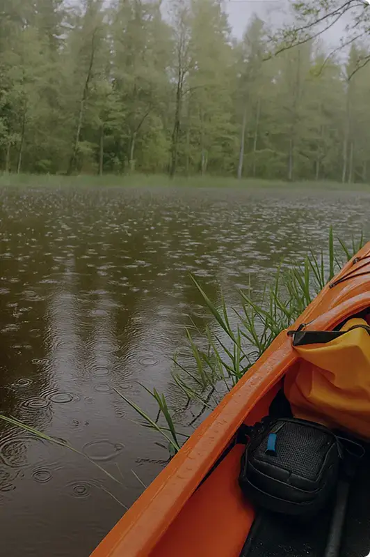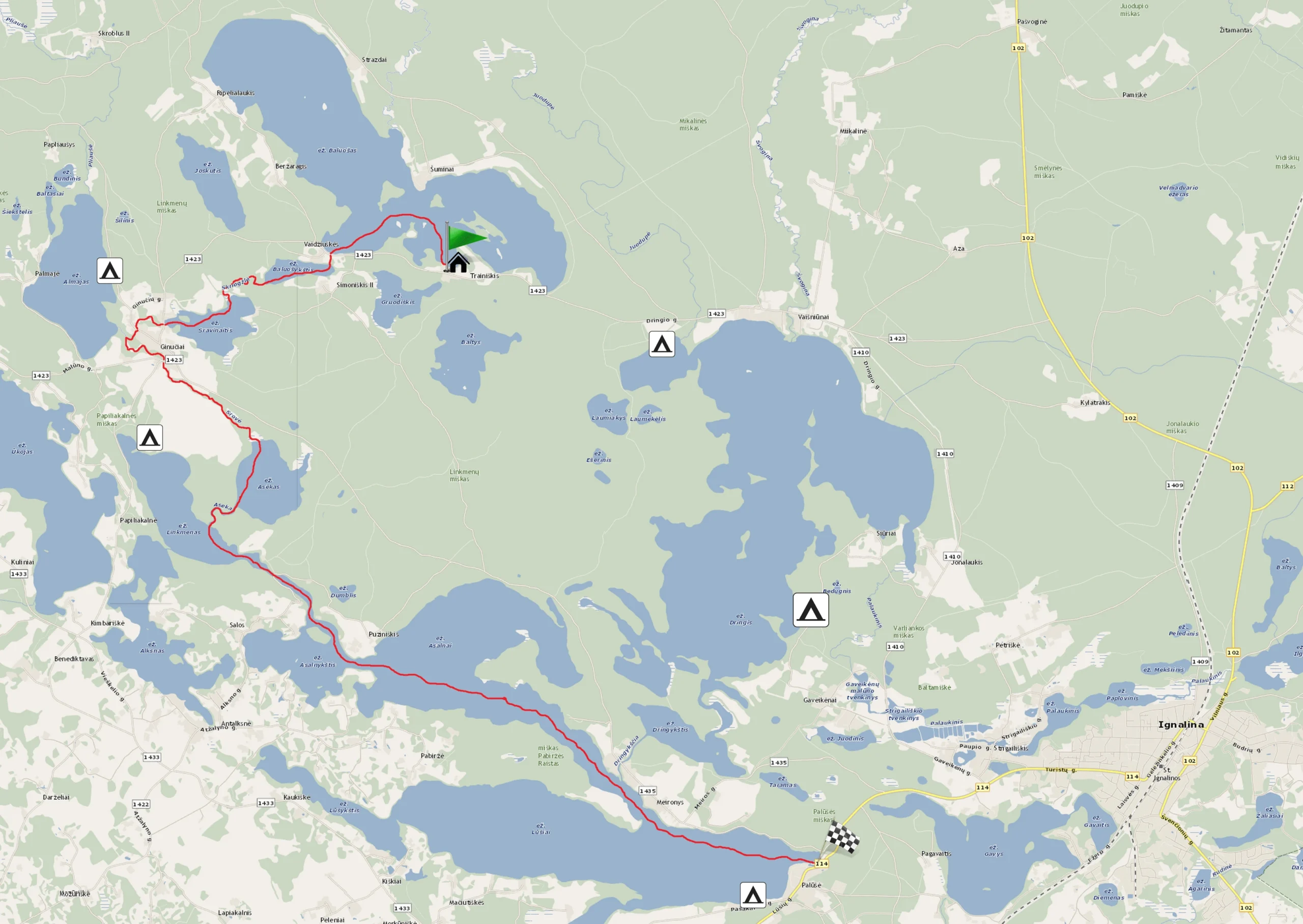
Būka River and Lakes (from Trainiškis to Palūšė)
You’ll see 7 islands of Lake Baluošas, wash off in the stream of Ginučiai Water Mill, and visit the ancient Palūšė church with its bell tower.
10.00 – 20.00 €
- ~ 8.2 hours
- ~ 24.6 km
Inquire and book canoes
The "Trainiškis – Palūšė" route is ~24 km. You'll paddle for ~8 hours.
Exiting the Trainiškis bay, on the left side you’ll see another small promontory. From there, paddle straight towards another, larger promontory visible in the distance. After rounding it and always keeping to the left shoreline, you’ll enter a large Baluošas bay, at the end of which you’ll see a stream about 150 m long, connecting Baluošas Lake with Baluošykštis Lake. This swift stream will carry you into another adventure-filled lake area.
Paddle along Baluošykštis until you reach the lake’s outlet, leaving Simoniškis village on the left and Vaidžiškiai village on the right. After crossing the lake, slightly to the left, among the reeds, you’ll notice the source of the Skriogžlė stream.
Skriogžlė is about 0.9 km long. Skriogžlė may seem like a narrow and deep river with several sharp bends. The banks of this river are covered with trees, making the river slopes quite steep. Storms have knocked several trees into the river, but you can overcome them by jumping with your canoe if you gain enough speed. After a few more bends, you’ll enter Lake Sravinaitis.
In Lake Sravinaitis, keep to the right shoreline until you reach an island shaped like a promontory. Bypass it on the left (the island will remain on the right), and you’ll reach the famous Ginučiai watermill.
The Ginučiai mill operated until 1968. A decade later, it was restored. Now the mill is declared a state-protected 19th-century technical monument. It houses a museum where you can see authentic old mill equipment. The mill museum is open from May to October (Tuesday to Saturday 10 am – 6 pm, Sundays 10 am – 3 pm).
Disembark on the right side of the watermill dam and carry your canoes over the dam. Don’t miss the great opportunity to swim in the water stream falling from the dam’s trough!
After splashing in the strong stream of the water mill, you’ll get into the transferred canoes and continue paddling on the Srovė River. Upon reaching the right tributary of the Almaja River from Lake Almaja, the Srovė River’s course will bend to the left. Beyond the river bend, you’ll pass the village of Ginuciai and the piers stretching into the river, along with two driveable bridges. As you pass the village, the river’s course will be straighter, and after navigating a few graceful turns, you’ll reach Lake Aseko. In Lake Aseko, keep to the right bank. After paddling more than half a kilometer, you’ll see the mouth of the Aseko River. This short river, about 650 meters long, connects Lake Aseko and Lake Linkmenas. Although Aseko has a wide bend, the current here is very weak. Moisture remains on the riverbanks due to abundant vegetation, making these areas home to beaver families.
The Asėka River will carry you into Lake Linkmenas.
Here you can choose several options: either continue the route without breaks or paddle to Papiliakalnė to look around from Ladakalnis.
If you want to visit Ladakalnis, you need to paddle to the opposite lake shore, deviating slightly to the right (on the map, Ladakalnis is marked with a red dot). Ladakalnis is a hill rising 176 m above sea level, from which you can count the lakes visible to the horizon. You’ll paddle about 1 km to Ladakalnis. However, you’ll forget about the distance when magnificent views open up before your eyes from the top of Ladakalnis: vast forest expanses, lakes hidden in the woods – Asėkas, Linkmenas, Alksnaitis, Alksnas, Ūkojas, and Pakasas will refresh your soul. Here you’ll gather strength for further travel through the lake-rich Aukštaitija.
After visiting Ladakalnis, paddle across Lake Linkmenas, keeping more to the right side. In the distance, you’ll see the Unkštis strait, connecting Linkmenas and Asalnykštis lakes.
If you didn’t visit Ladakalnis and have just arrived from the Asėka River, turn your canoes left and keeping to the left bank, after about half a kilometer, you’ll reach the Unkštis strait, connecting Linkmenas and Asalnykštis lakes.
Entering the Unkštis strait, you’ll paddle a little over 1 kilometer, and halfway through the strait’s trajectory, you’ll pass under a wooden pile bridge. This bridge connects the Salų peninsula visible on your right with the age-old Linkmenai forest on the left.
The Salų peninsula is special because it houses two villages: Salos I and Salos II. Both are in a kind of peninsula, washed by the Asalnykštis, Linkmenas, Alksnas, and Alksnaitis lakes. The only road for the peninsula’s village residents to travel by land leads from the village of Antalksnė. The Salų villages stand out for their unique architecture and layout, so a cultural reserve has been established here. Unfortunately, only a house and a barn from the 19th century remain. Other buildings were built in the early 20th century.
The peninsula we’re talking about is on your right as you paddle. On the left is also a very interesting historical site – the Puziniškis hillfort, covered with pines and birches, against which the aforementioned wooden bridge leans. The steep, up to 20 meters high, slopes of the hillfort are surrounded by remnants of a defensive rampart from the west. Perhaps you’d like to visit here too?
While deciding whether to paddle further or climb the hillfort, look at the water lapping the strait’s banks: you’ll see green organisms attached to various places, resembling corals. These are freshwater sponges – Lake Sponges (Spongilla Lacustris). Lake sponges and corals are related fauna, classified as simple invertebrates.
The strait is only one kilometer long, but around it are full of natural wonders and ethnographic objects. After overcoming the Unkštis strait, you’ll paddle into Lake Asalnykštis.
When you enter Asalnykštis, don’t get lost – keep to the left shoreline, and as you paddle in the right direction, Gimžiškės Island will wave on your right. As you paddle, you’ll see a strait in the distance, which, after crossing, will lead you into Lake Asalnai. On the left side of the strait, you’ll see the village of Puziniškis. This area also has its interesting history: in 1919, when Poland occupied the Vilnius region, a demarcation line separating Lithuanian and Polish-occupied territories ran through this village. The village of Puziniškis is located on a hill, from which a stunning view of the Asalnai landscape reserve opens up. After crossing the strait dividing the lakes, you’ll enter Lake Asalnai.
In Lake Asalnai, paddle straight, keeping to the right shoreline. Paddling in this direction, you’ll notice that this part of the lake begins to narrow. When you reach the narrow part of the lake (like a sleeve), on the left side, you’ll see the Dringykščia River (also known as Meira). The river flows from Lake Dringykštis, and just beyond the river, the sun warms the roofs of the farming village of Meironys, which will accompany you until you enter Lake Lusiai.
There is an interesting tradition in the village of Meironys: during Pentecost, farmers decorate their cows with flower wreaths and float them to the opposite cape’s shore, which locals call Pabiržis. There, the cows are released to graze freely until autumn and are floated back during Michaelmas. Milkmaids row by boat every morning and evening to milk the cows and bring the warm milk home.
So, after passing the village of Meironys on the left and Pabiržis cape on the right, you’ll enter Lake Lūšiai. From this point, keeping to the left shoreline, paddle ~1.5 km to the eastern shore of Lake Lūšiai towards the village of Palūšė.
Palūšė village is your finish line! At the finish line, we recommend visiting the Palūšė church with its bell tower, as it is the largest historical landmark of the village—a wooden church with a bell tower built in 1750! Climbing the stone-paved stairs, you’ll see that the church is well restored and cozy. The church stands on a hill, offering a pleasant view of Lake Lūšiai.