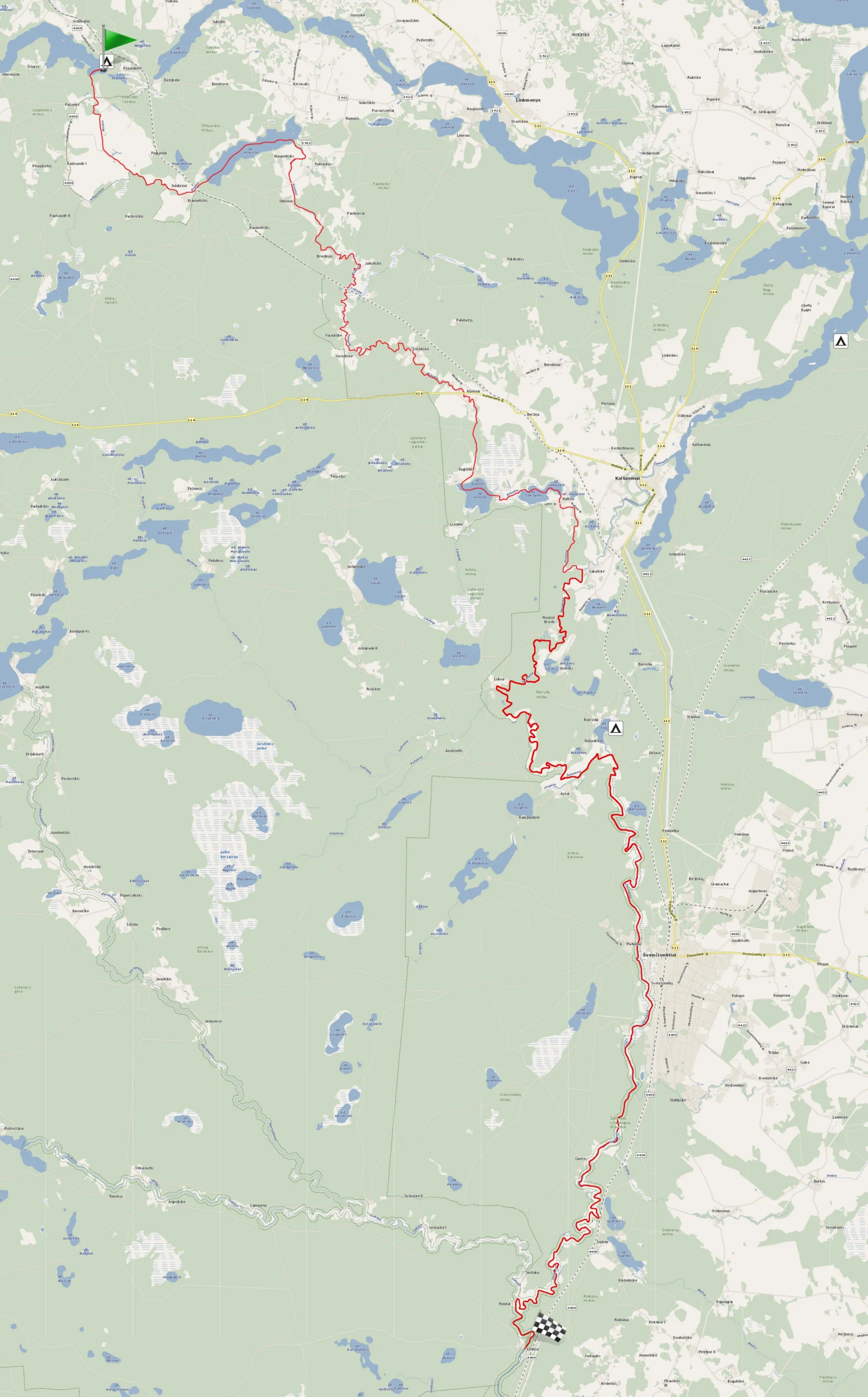
River Aiseta – River Kiauna – River Žeimena (Lake Aisetas to Liūlinė km.)
You’ll visit the Kiauna Landscape Reserve and meet the demonstrative Swans of Gilučio and Sekluočio lakes. You’ll pass through Švenčionėliai, which was almost destroyed by fire over 100 years ago but rebuilt within decades. The town was known for its good railway connections and industrial city. After reconstruction, it survived the consequences of World War II. Read more
10.00 – 20.00 €
- ~ 16.1 hours
- ~ 48.1 km
Inquire and book canoes
First day's route (~15 km; ~5 hours): From Lake Juodieji Lakajai, via River Kiauna to Lake Sekluočio.
Second day's route (~14 km; ~4.7 hours): From Lake Sekluočio via the Žeimena River to Lake Telio.
Third day's route (~19.1 km; ~6.4 hours): From Lake Telio to Liūlinė km. paddling along River Žeimena.
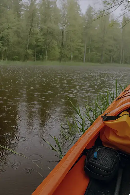
The rivers of Eastern Lithuania – Aiseta, Kiauna, and Žeimena – are for those who are not inclined to spend much time paddling through lakes or visiting mounds and other well-known sites. Kiauna will appeal to those seeking more extreme experiences – it is one of the most winding rivers in Eastern Aukštaitija, stretching through the Labanoras forests and marshes. The two-day canoe trip starts at a campsite located at the end of Lake Aiseta, known for its pleasant landscapes.
First day’s route
From Lake Juodieji Lakajai, via River Kiauna to Lake Sekluočio (~15 km; ~5 hours).
Aiseta Lake – second largest in the list of Lithuania’s longest lakes. When you’re ready to travel, hop into the canoes and paddle along the left bank of Aiseta. You’ll paddle 145 m to the very source of Aiseta River.
After paddling less than half a kilometer from the source of the Aiseta River, you will pass under a wooden bridge belonging to the village of Paaisetė. Later, you will pass by a few homesteads, navigate a few bends of Aiseta, and after ~0.6 km, the riverbed will become straighter for ~1.3 km. You will recognize this section by the reeds growing on the banks of Aiseta. After this exotic section, the riverbed will become more winding until the Utena – Švenčionėliai railway bridge. After passing under this bridge, you will see the remains of the old railway tracks. The Kiaunas Lake is already nearby, but you will still have to overcome a 260 m section of Aiseta’s natural obstacles, “strewn” with wooden barricades. After overcoming all this, you will enter Lake Kiaunas.
In Lake Kiaunas, direct the canoes along the right bank. You will recognize it by the lush pine forest growing on the banks, where the echo of vacationers resonates perfectly.
After paddling almost 2 km in Lake Kiaunas, always keeping to the right bank line, you will find the source of the Kiauna River. After paddling ~100 m from the source, you will see a small island overgrown with reeds.
Kiauna is a winding and fun river for water tourists, where we wish you pleasant adventures!
After paddling about 0.4 km on the Kiauna River, you will pass the village of Pakiaunys on the left. It has an ancient wooden manor homestead built between 1900 and 1903. The homestead is ~150 m away from the river.
Continuing the journey at the end of the village of Pakiaunys, you will pass under a bridge and immediately enter the Kiauna Landscape Reserve. You will encounter the nature of the reserve as you paddle further along the Kiauna River: the shores will delight you with rich vegetation, forests feeding the river, and you will pass marshes, which are an integral part of our nature. In spring, you will see dams built by beavers from branches, other terrestrial vegetation, mud, water grasses, and other materials these “builders” find in nature. After admiring the beavers’ “architecture,” you will pass many villages: Stirnines, Briedines, Jakutiškis, Vasiuliškės village, and further on – Žvirbliškė, Kūrinių village, recognizable by the road bridge.
From the aforementioned Vasiuliškės village, the more thrilling experiences begin: you’ll pass fallen trees, swift bends, and stone “obstacles.” Maybe you’ll get lucky and take a dip in the swift Kiauna current! The more adventure-filled stretch of the trip will continue until the Kūrinių village bridge.
When you paddle under the Kūrinių village road bridge, connecting the Molėtai-Ignalina road, you’ll paddle the winding Kiauna for about 2 km, with trees that have grown there for a long time leaning along the shores. The riverbed will gradually become straighter, adorned with a pleasant tree alley, leading you into Lake Gilūtas.
With the help of the current, paddle to Gilūta, direct the canoes to the left – east direction and paddle ~0.6 km to the lake’s channel. The length of the lake’s channel is ~800 m. Continuing along it, you would reach Lake Sekluočio.
On the right side of the channel, you will see a cozy sandy shore. Here you can take the opportunity to wade, swim. In this rest area, you can settle for the night to gather strength to complete the remaining part of the route.
The next day, before leaving, check if you have left any trash at the campsite!
Second day’s route
From Lake Sekluočio via River Žeimena to Lake Telio (~14 km; ~4.7 hours).
After passing the channel and entering Sekluotis, you’ll likely be greeted by elegant swans. Paddle along Sekluotis – heading east. This lake isn’t very deep, so the canoe bottoms will brush against tall water grasses. Now you probably understand why the lake got its name J. After paddling about 0.75 km, as you approach the shore, steer the canoes to the right – heading south. Then paddle to the river flowing from Sekluotis Lake.
This small stream is part of the Kiauna River but is sometimes called Kernauja. You will soon see the village of Kukliai, embracing the riverbanks. In Kukliai, before reaching the concrete bridge, you will find a convenient shore for disembarking on the right side, in a meadow where you can rest.
Continuing towards the Žeimena River, the banks of Kiauna will be lined with pine forests. After paddling about 2 km from the village of Kukliai, the current will slow down, gradually carrying you to the mouth of the Kiauna River. Kiauna is the first right tributary of the Žeimena River.
You will enter River Žeimena at the confluence of Kiauna and Žeimena near the village of Šakališkės. At the confluence, you can turn left to disembark on the shore of Šakališkės village after 400 m, or a bit further (3 km from the confluence) in the town of Kaltanėnai. Here you can visit the Kaltanėnai church, built from red clay bricks, distinguished by its early 20th-century neo-Gothic style. The church was built between 1903 and 1909.
If you’re not interested in sightseeing, stick to the main channel of River Žeimena (you’ll be paddling downstream). After passing the tributary and rowing ~1.7 km, you’ll pass another small village – Naujoji Brasta. Another ~3 km further, you’ll find Luknos village, where the second right tributary of Žeimena – Luknelė – flows. Although this river is short (~15 km), it is very extreme: full of tree barriers, difficult to navigate, so we don’t create routes on this river. After paddling ~5 km from the Luknelė tributary, on your right side, you’ll see Jusių village. Next to this village is the third right tributary of Žeimena – the Sirgėla river, with its mouth overgrown with reeds. This river is short, characterized by a weak current, flowing from the Sirgelis pond.
At the mouth of the Sirgėla River, the territory of the Aukštaitija National Park ends, and the Žeimena ichthyological reserve begins. It extends to the confluence of the Žeimena and Neris rivers. The purpose of the ichthyological reserve is to protect spawning grounds for salmon, sea trout, and brown trout.
After paddling about 1 km from the mouth of the Sirgėla River and navigating two sharper bends of the Žeimena, you’ll pass the left tributary of the Žeimena—the short Šventelė River, which carries the waters of Lake Telio. Turn left into the Šventelė River to enter Lake Telio. In Lake Telio, keep to the right shoreline, and after paddling more than half of the lake’s shore, you’ll find a campsite beyond the peninsula.
Third day’s route
From Lake Telio to Liūlinė km. paddling along River Žeimena (~19.1 km; ~6.4 hours).
From the Telio Lake campsite, return to the Šventelė River, keeping to the left bank. From the Šventelė River, you’ll quickly reach the Žeimena.
About ~5 km from the confluence of Šventelė and Žeimena, you’ll reach the shores of the town of Švenčionėliai.
Švenčionėliai were mentioned in written sources in the 17th century. at the end. In the northern part of the town, there was Juodiškis manor and a village around it during the Middle Ages. The town’s growth was spurred by the construction of the Saint Petersburg – Warsaw railway in 1862 and, of course, the railway station. A narrow-gauge railway from Panevėžys to Lentupis, reaching Adutiškis, was also built through the town. Unfortunately, the settlement, known for its railways, almost completely burned down in 1900. almost completely burned down. After quickly rebuilding it, industrial enterprises began to develop, and by 1907, a wooden church cross rose above the town’s roofs, and a school was established. The town’s expansion didn’t stop, so in 1920, Švenčionėliai received town rights. Four years later, a matchstick factory began operating. World War II caused significant damage to Švenčionėliai: over 200 buildings were destroyed, and in 1941, 8,000 people were shot in the forest across the Žeimena. However, Švenčionėliai is a constantly reborn town, so after the war, it was quickly rebuilt. In the town, you can buy food, medicine, books, and enjoy your time in cafes.
If you wish, when you reach Švenčionėliai, disembark before the first bridge, known locally as Kirulis Bridge. In front of it, there’s a convenient sandy bathing area.
Continuing the journey, paddle along the Žeimena River towards the village of Liūlinė. From Švenčionėliai, the river is supplemented by marshes and forests. Here and there, you’ll pass river bays—don’t confuse them with the confluences of other rivers. You’ll recognize the true course of the Žeimena by the flow of the water and the movement of vegetation in it.
After covering about 8 km from Švenčionėliai, you’ll see the village of Garnys on the right. After passing the settlement, you’ll feel that the Žeimena becomes increasingly winding. After paddling the remaining trajectory, you’ll reach the confluence of the Lakaja and Žeimena. On the right side of the river confluence, you’ll see a village called Santaka. From here, paddle about 1.5 km to the finish line, and you’ll reach the village of Liūlinė, where your finish is! Immediately after passing under the concrete bridge, dock on the right side.